Hydrogeological Map 1:100’000
In its representation of the subsurface, the Hydrogeological Map 1:100‘000 (HyGeo100) combines the data of three related disciplines: geology, hydrology and hydrogeology. In particular, the occurrence and flow conditions of water in the subsurface are documented.
Elements of the HyGeo100
The HyGeo100 describes the occurrence and flow conditions of groundwater. Geological criteria and the hydraulic conductivity form the basis for the regional rock classification. Supplements to these data include the depiction of aquifers as well as hydrogeological point and line data, such as springs, groundwater levels and hydraulic connections.
A superordinate planning tool
The HyGeo100 is based on detailed hydrological and hydrogeological datasets (e.g. cantonal water-protection and groundwater maps), which have been harmonized and generalized. With the selection of the scale at 1:100,000, visualization of entire cantons or regions is possible. The work thus serves as a superordinate planning tool for the federal government, cantons and private offices.
Coverage, products
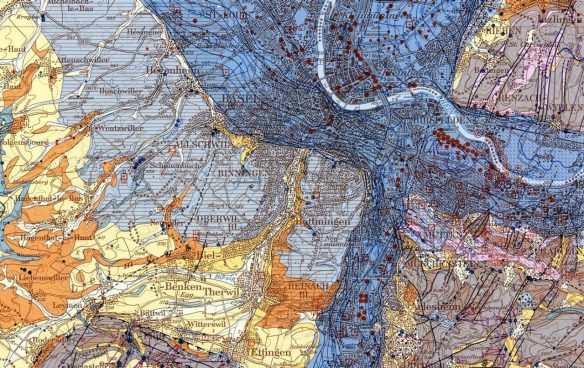
Since 1972, eight map sheets covering the Jura Mountains and the Swiss Plateau between Lake Geneva and Lake Constance have been published in collaboration with the Federal Office for the Environment (FOEN), swisstopo and the Swiss Geotechnical Commission (SGTK). The most recent one is the Basel – Bâle sheet, published in 2014.
All of the map sheets are available as cost-free raster data at the FOEN. At swisstopo they can be purchased as printed map sheets. The raster data are also accessible through the map viewer of the federal geoportal.
In addition to the raster data, the map sheets of northwestern Switzerland (Biel – Bienne, Sarine / Saane, Vallorbe – Léman nord and Basel – Bâle) are available as a vector dataset (HyGeo100 NW Switzerland). A new data model serves as a basis for converting the individual map sheets into a seamless, homogenized vector dataset. This dataset can also be obtained free of charge from the FOEN.
Links to sources of supply
Federal Office for the Environment (FOEN), general information about hydrogeological maps
Federal Office of Topography swisstopo, printed map sheets (swisstopo onlineshop)
Links to further information
Federal Office for the Environment (FOEN), hydrogeology (publication in German)
Swiss Hydrogeological Society (SGH)
Abstract, Swiss Geoscience Meeting 2015 (PDF, No. 18.2)
Article about new groundwater data in Geopanorama 3/2016 (PDF, p. 19)